


Description
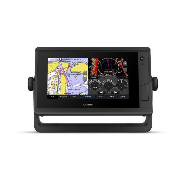
Garmin GPSMAP742 Plus 7″
Plotter with BlueChart US g3 and Lakevu HD
Model: 010-02320-01
- Easily integrate with more engines
- Connect to your favorite third-party devices
- Easily build your marine system using the best of network connectivity
- Navigate any waters with preloaded mapping and coastal charts
- Take the guesswork out of sailing with clear laylines and more right on the screen
- Manage your marine experience from nearly anywhere
The bright, sunlight-readable 7" intuitive touchscreen chartplotter with enhanced map drawing is easy to use in any environment and seamlessly integrates into your Garmin marine system.
Experience unparalleled coverage and detail with preloaded BlueChart® g3 coastal charts and LakeVü g3 inland maps featuring integrated Garmin and Navionics® content and Auto Guidance1 technology.
OPTIONAL BLUECHART® G3 VISION® CHARTS – Upgrade to our reliable premium charts, which add even more industry leading features, such as high-resolution relief shading, to help you on each trip.
View laylines, race start line guidance, enhanced wind rose, heading and course-over-ground lines, true wind data fields and tide/current/time slider, wind angle, set and drift, wind speed and more.
If you have multiple Garmin devices on your boat, you can share information — such as maps, user data, radar and IP cameras — among them.
Connect to autopilots, digital switching, weather, FUSION-Link™ audio system, media, VHF, AIS and more from one screen.
Built-in Wi-Fi® connectivity pairs with the free all-in-one mobile app for access to the OneChart™ feature, smart notifications2, software updates, Garmin Helm, Garmin Quickdraw™ Community data and more.
Connect with some of your favorite devices, such as quatix® marine watches, gWind™ Wireless 2 transducers, GNX™ Wind marine instruments and wireless remote controls.
Now you can connect your chartplotter to different kinds of engines, including Yamaha engines.
ONEHELM™ FEATURE – This exclusive feature brings together all the operations and capabilities of third-party devices, such as EmpirBus™ digital switching, on one screen.
Pair with Panoptix or Panoptix LiveScope™ easy-to-interpret live sonar (transducer sold separately) to see all around your boat in real time.
Specifications
| General | |
| Physical dimensions | 8.8″ x 5.6″ x 2.1″ (224.0mm x 142.5mm x 53.9mm) |
| Display size | 6.1″ x 3.4″; 7.0″ diagonal |
| Display resolution | 800 x 480 pixels |
| Display type | WVGA display |
| Weight | 2.4 lbs (1.1 kg) |
| Water Rating | IPX7 |
| Polarized Support | Yes |
| J1939 Compatible | Yes |
| Power consumption | Max power usage at 10 Vdc: 24 W |
| Antenna | Internal or external over NMEA 2000 |
| Mounting options | Bail or flush |
| Receiver | 10 Hz high-sensitivity |
| Garmin Marine Network™ ports | 1 |
| Maps & Memory | |
| Preloaded maps | BlueChart® g3 (coastal maps) and LakeVü g3 (inland maps) |
| Accepts data cards | 2 microSD™ cards; 32 GB max |
| Waypoints | 5,000 |
| Routes | 100 |
| Track log | 50,000 points; 50 saved tracks |
| Outdoor Recreation Features | |
| Tide tables | Yes |
| Chartplotter Features | |
| Garmin Radar compatible | Yes |
| Garmin Sonar compatible | Yes (with external black box, sold separately) |
| Garmin SmartMode compatible (customizable monitor presets) | Yes |
| Supports AIS (tracks target ships position) | Yes |
| Supports DSC (displays position data from DSC-capable VHF radio) | Yes |
| Supports FUSION-Link™ compatible radios | Yes |
| GSD™ Black Box sonar support | Yes |
| GCV™ Black Box sonar support | Yes |
| ActiveCaptain compatible | Yes |
| GRID™ (Garmin Remote Input Device) compatible | Yes |
| Wireless remote compatible | Yes |
| Sailing Features | Yes |
| Sonar Features & Specifications | |
| Dual-frequency (50/200 kHz) sonar capable | Yes (with external black box, sold separately) |
| Dual-beam (77/200 kHz) sonar capable | Yes (with external black box, sold separately) |
| CHIRP sonar technology | Yes (with external black box, sold separately) |
| ClearVü | Yes (with external black box, sold separately) |
| SideVü | Yes (with external black box, sold separately) |
| Connections | |
| NMEA 2000® compatible | Yes |
| NMEA 0183 input ports | 1 (Differential) |
| NMEA 0183 output ports | 1 (Differential) |
| Video input ports | 1 BNC |
| Video output ports | None |
| Wireless connectivity | Yes |
What’s in the Box:
- GPSMAP 742 Plus chartplotter
- Power cable
- Bail mount with knobs
- Flush mount kit with gasket
- Protective cover
- Trim piece snap covers
- Documentation


